
New Tool Offers Interactive Watershed Group Search
Source: Ohio Watershed Network
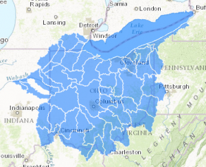 The Ohio Watershed Network has created an interactive map as part of the Watershed Group search feature.
The map allows users to zoom and click on any of the 8-digit Hydrologic Unit Code watersheds in Ohio. Selecting a watershed will create a popup box with the HUC-8 code, watershed name, and a link to “More info.” Selecting the “More info” link provides a list of watershed groups that operate within that 8-digit HUC.
Watershed groups can be found using the name search, HUC-8 or HUC-11 code for the watershed, county, or via the clickable map.
To see the map, go to http://ohiowatersheds.osu.edu/node/1694.
(Note: the map is hosted on another site (ESRI) and takes a few seconds to load.)

